Tuesday July 14th
Trail Leader: Bill & Nancy
Plan to meet at the County Super Market located at 900 Moraine Ave, Estes Park, CO 80517. It is on the corner of Moraine Avenue (Highway 36) and Marys Lake Road. It is right before the main entrance to Rocky Mountain National Park. We will decide on a meeting time on Monday the 13th. Please note it is NOT the entrance we used on Monday. It will be about a 45 minute drive to get to this area which means an earlier start for the group as there should be enough trails for an all day ride. Plan on a long day!! Pack a lunch and be sure to top off your fuel tank as well before we head out.
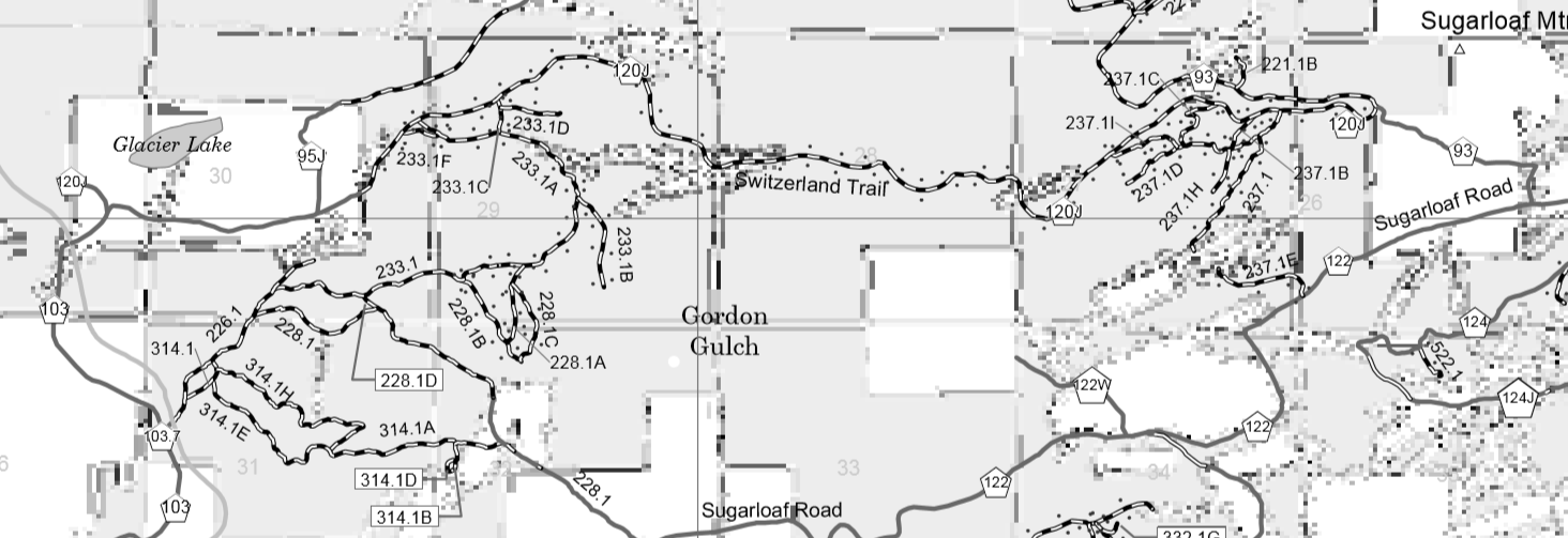
The US Forest Service map is a good resource which can be download for free – here is the link for the North and a link for the South. These maps cover not only the Switzerland trail system but many others. We have also included GPX files for those with a GPS.
Happy Trails to you!
Bill & Nancy
The US Forest Service map is a good resource which can be download for free – here is the link for the North and a link for the South. These maps cover not only the Switzerland trail system but many others. We have also included GPX files for those with a GPS.
Happy Trails to you!
Bill & Nancy
Switzerland Trail/FR327
Overview:The Switzerland Trail is an old railroad grade that zigzags across the mountains of Boulder County. The narrow-gauge railroad transported people, supplies and ores between the City of Boulder and the county's mining communities, including Gold Hill, Ward, Cardinal, Nederland and Eldora from 1883 to 1919. The rails have long-since been removed, but many people today enjoy driving and riding this route. Not all of the extent of the old railbed is open to motorized use.
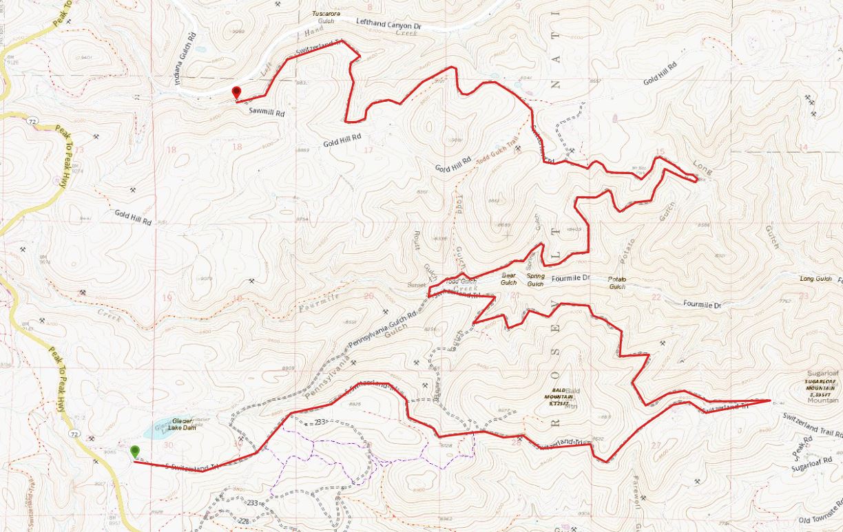
The main Switzerland trail goes for many miles and is easy to drive. There are several trails that come off the main trail that range from moderate to extreme. This trail will take you by beautiful Gold Lake, the living ghost town of Sunset. On its own, Switzerland Trail is an easier out and back route for beginner off-roaders and basic four-wheel drive vehicles. The gradual climb through the rolling mountain meadows of Roosevelt National Forest offers plenty of optional side road challenges and it runs into Pennsylvania Gulch—one of the area’s most difficult and rewarding drives. Mount Alto Picnic Area is adjacent to this road.
Moderate 9.3 miles
History:
Near Sugarloaf Mountain, the town of Sugarloaf once existed. It started in the early 1860s when prospectors found gold ore and used an arrastra to crush the ore to free the gold. Once the surface ore was depleted the area was abandoned. In 1873 another boom took place when tellurium containing gold and silver was discovered. The Livingston Mine near Sugarloaf produced $300,000 worth of gold. After it closed a prospector named Miles discovered rich gold ore in 1902 in a potato patch close to the old mine. In a week Miles prospected $20,000 from the potato patch using a scraper. Of course the mine was named the Potato Patch. In 1915 the United States Gold Corporation constructed a large cyanide mill near Sugarloaf to process low-grade ore. By 1940 the mill was closed and during World War II the equipment in the mill was pulled during a scrap drive.
Because the Colorado & Northwestern could not make it on the revenue from hauling mine ore, it turned to tourists to finance the line. A 20x30 foot depot, sidings and a wye were installed at Sunset. The Columbine Hotel in Sunset put up the tourists and kept them fed in the large dining hall. In 1909, the Colorado & Northwestern Railroad was replaced by the Denver, Boulder & Western, often dubbed the "drink beer and wine" by its carefree passengers. In 1919 a flood washed out miles of track and took out some of the railroad bridges causing the line to shut down and the tracks pulled up leaving the rail road grade as a rough road. The demise of the line came from a variety of factors, including: the extremely harsh winter conditions in the Rocky Mountains, which limited the tourist trade to about four months per year, forced frequent line closures, and periodically killed train crews, plus the advent of the automobile and the closure of the surrounding mines.
Starting off of Hwy72 north of Nederland, the Switzerland Trail railroad grade heads east past Glacier Lake. At one time there was a tourist pavilion and railroad "Y" at Glacier Lake, today it is private property. This section of County Rd 120J has fencing and private property signs along the road. In about a mile we will be back on public lands. On the north side you will pass an intersection with County Rd 95J which heads down to Sunset. The road will follow a ridge eastward working its way along hills and the top of short gulches. For the most part the road is a two lane natural surface road with rocks and pot holes strewn along the way.
Trail Description:
As the group continues east we will pass the Gordon Gulch, FR233, road to the south. There are two spurs that tie into the Gordon Gulch area. Further along on the north side of the road will be the closed Bear Gulch, FR235, 4WD road. It was damaged in the 2013 flood, and was revegetated by the Forest Service in 2014. There are a few spurs up onto the flank of Bald Mountain and the Farewell Gulch, FR237, road network on the south side of the road. Less than a mile past these side roads we will come to a large intersection. To the south is an access through private property to the Sugarloaf Road and County Rd 122. To the east is a closed road that use to go up to the top of Sugarloaf Mountain. When Boulder County took possession of Sugarloaf Mountian in 1994 they closed the old road. To the north is the continuation of the Switzerland Trail as County Rd 93.
From the saddle below Sugarloaf Mountain the railroad grade begins its descent down to Sunset, a small town in Four Mile Canyon below. There will be a few tight section along this part of the road where the railroad grade cuts through small hills and loops into gulches. The road will be a bit more rocky as we head down. In Sunset we will cross County Rd 118 and then head back up past some private homes. The Switzerland Trail will now climb up the north side of the valley. This section has more views to the south as a large part of the railroad grade is in more open terrain. The road will get narrower and there will be a few tight curves. There are only a few "cuts" into the hillsides for the railroad grade. After heading northeast making the ascent up to the top of Potato Gulch, the road will loop around and head back west toward Mount Alto Picnic Ground. All that remains of this once large pavilion, quartz fountain, and picnic area is the stone fireplace. There is a parking area with the old remains of the quartz fountain along its access road. we will either have lunch here or at least a place to get out and stretch a bit.
After we leave Mount Alto the group will continue west. The road will become mainly a ledge road as it works its way toward County Rd 52, the Gold Hill Road. We will pass a road network on the north side of the Switzerland Trail, the Mount Alto network, FR456, that climbs up a steep hill and works its way through the forest to County Rd 52. The railroad grade will make a sweeping curve through a large "cut" in the mountain that opens onto a fill that crosses a small gulch. From here it is a short distance to County Rd 52.
To continue on the Switzerland Trail, cross County Rd 52. This is now FR93. It will loop around a large hill passing an intersection with the Knob, FR458. Continue on FR93, the Switzerland Trail road. We will cross over a few more railroad fills as the grade works around the hills. Finally we will come to an intersection with Sawmill Cutoff, FR461. The railroad grade goes another 0.25 miles to where it ends as a road. Take the Sawmill Cutoff to the left and climb a hill to the top of the ridge. From here the Sawmill Cutoff road heads southwest to the Sawmill Road, County Rd 95. If we take County Rd 95 down hill to the north toward Ward we would cross a section of the railroad grade. This last part of the Switzerland Trail from where FR93 ends, is not drivable. It looped to the west around the wide valleys and came into Ward from the south following along Hwy72. Some of the railroad grade is still visible from Hwy 72 down in the gulches we crossed.
Pennsylvania Gulch
Overview:
The group had lunch before a couple of Jeeps headed up the trail to explore.. An excellent choice to challenge experienced off-road drivers, Pennsylvania Gulch can be reached at the top of Switzerland Trail and absolutely requires a four-wheel drive vehicle. On the trail, we will encounter rocks and exposed tree roots with only about two places to easily pass other vehicles. Our group finally turned around before reaching the other end. It was a good trail but not Cherokee friendly.
Difficult 2.2 miles
Directions to Trailhead:
Trailhead Coordinates: 40.035603, -105.468925Starting Point: Switzerland Trail
Take Switzerland Trail North 3.9 miles. The Pennsylvania trailhead is on the left heading to the west. The trail ends on Sugarloaf Mountain Trail approximately 1/2 mile from CO Highway 72.


